- Region
- Águilas
- Alhama de Murcia
- Jumilla
- Lorca
- Los Alcázares
- Mazarrón
- San Javier
-
ALL AREAS & TOWNS
- AREAS
- SOUTH WEST
- MAR MENOR
- MURCIA CITY & CENTRAL
- NORTH & NORTH WEST
- TOWNS
- Abanilla
- Abarán
- Aguilas
- Alamillo
- Alcantarilla
- Aledo
- Alhama de Murcia
- Archena
- Balsicas
- Blanca
- Bolnuevo
- Bullas
- Cañadas del Romero
- Cabo de Palos
- Calasparra
- Camping Bolnuevo
- Campo De Ricote
- Camposol
- Canada De La Lena
- Caravaca de la Cruz
- Cartagena
- Cehegin
- Ceuti
- Cieza
- Condado de Alhama
- Corvera
- Costa Cálida
- Cuevas De Almanzora
- Cuevas de Reyllo
- El Carmoli
- El Mojon
- El Molino (Puerto Lumbreras)
- El Pareton / Cantareros
- El Raso
- El Valle Golf Resort
- Fortuna
- Fuente Alamo
- Hacienda del Alamo Golf Resort
- Hacienda Riquelme Golf Resort
- Isla Plana
- Islas Menores & Mar de Cristal
- Jumilla
- La Azohia
- La Charca
- La Manga Club
- La Manga del Mar Menor
- La Pinilla
- La Puebla
- La Torre
- La Torre Golf Resort
- La Unión
- Las Palas
- Las Ramblas
- Las Ramblas Golf
- Las Torres de Cotillas
- Leiva
- Librilla
- Lo Pagan
- Lo Santiago
- Lorca
- Lorquí
- Los Alcázares
- Los Balcones
- Los Belones
- Los Canovas
- Los Nietos
- Los Perez (Tallante)
- Los Urrutias
- Los Ventorrillos
- Mar De Cristal
- Mar Menor
- Mar Menor Golf Resort
- Mazarrón
- Mazarrón Country Club
- Molina de Segura
- Moratalla
- Mula
- Murcia City
- Murcia Property
- Pareton
- Peraleja Golf Resort
- Perin
- Pilar de la Horadada
- Pinar de Campoverde
- Pinoso
- Playa Honda
- Playa Honda / Playa Paraíso
- Pliego
- Portmán
- Pozo Estrecho
- Puerto de Mazarrón
- Puerto Lumbreras
- Puntas De Calnegre
- Region of Murcia
- Ricote
- Roda
- Roldan
- Roldan and Lo Ferro
- San Javier
- San Pedro del Pinatar
- Santiago de la Ribera
- Sierra Espuña
- Sucina
- Tallante
- Terrazas de la Torre Golf Resort
- Torre Pacheco
- Totana
- What's On Weekly Bulletin
- Yecla


- EDITIONS:
 Spanish News Today
 Alicante Today
 Andalucia Today
10km walking/cycling route, leaving from Cieza town
Route 1 La Isla– El Horno, from Cieza town
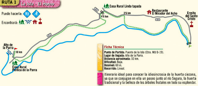
This is a cycling and walking route through Cieza which is an ideal way to discover the beauty of the Ciezan countryside enjoy the fruit orchards and agricultural areas of the municipality, including a section which runs alongside the Segura River. It also includes the hermitage of Santo Cristo, the lookout point and restaurant Mirador and the Acho restaurant, offering the chance to stop off and enjoy a cooling drink and a snack, as well as other places of beauty and interest along the route.
Departure point: Puente de la Isla (Isla Bridge) Carretera MU B-19
End point: Alto de la Parra
Distance: 10km approx.
Difficulty: low
Climb: 60m
Type of route: lineal
Click for map showing departure point, the Puente de la Isla.
This is right next to the watermill , the Molino de Teodoro, and there is parking in the carpark for the watermill. Click Molino de Teodoro
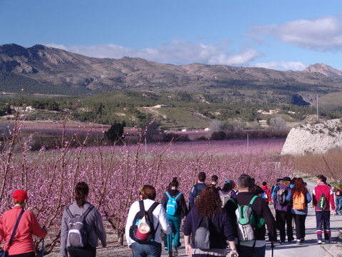
This route has particularly been designed to show off the beauty of La Floración during the spring when the peach orchards which surround the town are in blossom.
Print this page:This page can be printed. Use the icons block at the top of this article, select the plus sign and click, print is amongst the options given. The route can be compared to the google map link given and is clearly visible on the actual google map.
Click for further information about visiting Cieza. This includes accommodation options, places to visit and general information about the area: Click Cieza section
Share your pictures with us via our what's on facebook if you do go and enjoy yourself!
Join the Murcia What's On and Where to Go group on Facebook to keep up to date with all the latest events taking place near you: https://www.facebook.com/groups/MurciaWhatsOnAndWhereToGo/


