- Region
- Águilas
- Alhama de Murcia
- Jumilla
- Lorca
- Los Alcázares
- Mazarrón
- San Javier
-
ALL AREAS & TOWNS
- AREAS
- SOUTH WEST
- MAR MENOR
- MURCIA CITY & CENTRAL
- NORTH & NORTH WEST
- TOWNS
- Abanilla
- Abarán
- Aguilas
- Alamillo
- Alcantarilla
- Aledo
- Alhama de Murcia
- Archena
- Balsicas
- Blanca
- Bolnuevo
- Bullas
- Cañadas del Romero
- Cabo de Palos
- Calasparra
- Camping Bolnuevo
- Campo De Ricote
- Camposol
- Canada De La Lena
- Caravaca de la Cruz
- Cartagena
- Cehegin
- Ceuti
- Cieza
- Condado de Alhama
- Corvera
- Costa Cálida
- Cuevas De Almanzora
- Cuevas de Reyllo
- El Carmoli
- El Mojon
- El Molino (Puerto Lumbreras)
- El Pareton / Cantareros
- El Raso
- El Valle Golf Resort
- Fortuna
- Fuente Alamo
- Hacienda del Alamo Golf Resort
- Hacienda Riquelme Golf Resort
- Isla Plana
- Islas Menores & Mar de Cristal
- Jumilla
- La Azohia
- La Charca
- La Manga Club
- La Manga del Mar Menor
- La Pinilla
- La Puebla
- La Torre
- La Torre Golf Resort
- La Unión
- Las Palas
- Las Ramblas
- Las Ramblas Golf
- Las Torres de Cotillas
- Leiva
- Librilla
- Lo Pagan
- Lo Santiago
- Lorca
- Lorquí
- Los Alcázares
- Los Balcones
- Los Belones
- Los Canovas
- Los Nietos
- Los Perez (Tallante)
- Los Urrutias
- Los Ventorrillos
- Mar De Cristal
- Mar Menor
- Mar Menor Golf Resort
- Mazarrón
- Mazarrón Country Club
- Molina de Segura
- Moratalla
- Mula
- Murcia City
- Murcia Property
- Pareton
- Peraleja Golf Resort
- Perin
- Pilar de la Horadada
- Pinar de Campoverde
- Pinoso
- Playa Honda
- Playa Honda / Playa Paraíso
- Pliego
- Portmán
- Pozo Estrecho
- Puerto de Mazarrón
- Puerto Lumbreras
- Puntas De Calnegre
- Region of Murcia
- Ricote
- Roda
- Roldan
- Roldan and Lo Ferro
- San Javier
- San Pedro del Pinatar
- Santiago de la Ribera
- Sierra Espuña
- Sucina
- Tallante
- Terrazas de la Torre Golf Resort
- Torre Pacheco
- Totana
- What's On Weekly Bulletin
- Yecla


- EDITIONS:
 Spanish News Today
 Alicante Today
 Andalucia Today
Aledo, a geological walk through time
20 million years in a morning on the geological route in Aledo
For anyone with an interest in geology, Aledo is a fascinating area, rich in fossils and rock formations demonstrating the various stages which led to the creation of the Region of Murcia. The geology of Aledo has resulted in the area being listed as being of LIG, a location of geological interest, and this walk has been created as a route through 20 million years.
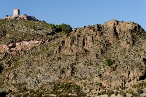
The first port of call is the rocky outcrop on which the castle keep of Aledo itself stands: on the south face of the outcrop, at the base of the tower, it is possible to see colonies of coral (Tarbellastraea sp.) interspersed with the fossils of exceptionally well-preserved lithophages (bi-valvular marine beings which live in the rocks, like sea dates) and fragments of oysters.
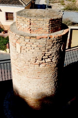
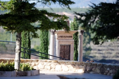 From the castle, head down towards a bronze sculpture of a door, which shows the cultural events and fiestas taking place in Aledo each year, and next to it is the Picota. This cylindrical brick structure is a pillory, a place of execution and public humiliation in the Middle Ages, and is the only one remaining in the region of Murcia.
Here again, the rocks which surround the pillory are full of fossils.
Follow the Calle de los Romanos, where there is a splendid view of the land to the west of Aledo, and in the rock out of which the street has been hewn it is possible to observe the debris which was transported by the Nonihay delta to the tropical beaches in the area which is now Aledo. Among the plentiful fossils which are well preserved in the rock are examples of bivalvia (Ostrea sp., Pecten sp., Clhamys sp., Spondylus, Cardium sp. etc.), large echinoderms (Clypeaster sp.) and vast accumulations of nummulites (Heterostegina sp.).
These organisms were for the most part transported here, crushed and piled up by the avalanches of sediment from the torrents gushing down from Sierra Espuña. This can be seen by the fact that, on close examination of the seven-million-year-old rock, it is possible to make out pieces of dolostone and red conglomerate which are far older than most of the rock, dating back 200 million years. Some of these fragments are quite large, and they are typical of the Baetic system which can be seen, for example, in the area of the Santuario de Santa Eulalia, further down the valley towards Totana.
 Further along the street is a darker layer of rock where manganese oxides have accumulated, and a whitish wall of rock. This is a joint through which water filtered, laden with calcium bicarbonate, and the dripping of the water has left a layer of calcite which has the appearance of false agate. This is a perfect example of how mineral deposits can be formed, and helps us to see the process almost at first hand.
Leaving the road and descending by a stony path which has been built recently, is a track which runs all the way round the hill of Aledo. Unfortunately, the track is not in prime condition, and on the eastern side of the hill there is such an accumulation of rubble that it is practically impassable. Even so, it’s worth following the path, as it gives an interesting alternative view of the hill and the base of the castle walls.
Here the yellowish sandstone of the Aledo formation can be seen: this arose from beaches which were the home of early living organisms in prehistoric times. It is still possible to see the evidence of these early animals, both in the fossilized shells which they left on the sea bed and, more especially, if we dig down into the small pits a couple of feet deep which were formed on the floor of the ocean. To touch the sand here is quite an experience: in many places it is still loose, and it’s almost possible to imagine the sea bed and the tropical beaches as they would have been millions of years ago.
By happy chance the action of Man in making this path has enriched the geological heritage of the area, since the rocks which have been used to strengthen the path contain striking examples of pyrolusite crystallization.
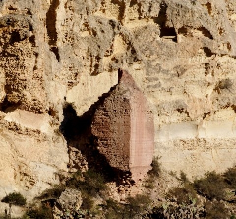 Further along the path we can enjoy the sight of other geological processes which are still ongoing today, such as weathering. These processes are shaping the walls here, leaving blocks of fallen rock, small foothills and fantastic examples of tangled hollows which are known as “tafonis”. There are also good examples of the faults which ran through the sandstone cliffs of the Aledo formation.
One very interesting feature of this landscape are the features created by water action. Under the permeable sandstone, which allows water to pass through the cracks in it, are the marine marls of the Carivete formation.
These are impermeable, and where the two layers meet there are small springs: the hill on which Aledo stands is a clear example of an aquifer which has become detached from the rest of the sub-structure and has remained in isolation.
One of the best examples of this is at the start of the route, where there is a gallery: if we climb up the hill a little we come across another gallery, which the locals refer to as "El Pozo de los Moros" . This was a system for collecting water from underground reserves, which made it possible for the castle of Aledo to withstand long sieges, and there are still remains of “La Torreta”, the tower which was used to defend this precious natural resource.
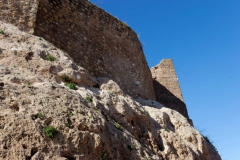 Moving along the path there is a chance to take photos of the base of the walls and the keep which looks out over the limestone escarpment. Those who wish for more geological features can go further down the hill to see the oldest rocks in the area, the marine sandstone of the Manilla formation and the red conglomerates of Carraclaca: with this the tour is complete, and we have seen a cross-section of all the rock types in this large sedimentary basin.
Those with vehicles may enjoy heading off down through the farmed areas of Aledo, which were terraced by the Moors and then into the Rambla itself. Leaving Aledo and heading towards the Sierra Espuña, there is a left hand turning. Shortly afterwards another left hand turning indicates a senderismo walking route: follow this down into the Arab terraces and the road leads out into the rough mountainside and the Rambla.
Mobile: 696 962 116

Oficina de Turismo de Aledo
The tourist information office of Aledo is located within the Torre del Homenaje, the keep of the castle at the top of the old town, and although it is possible to drive to within just a few metres of the tower and park in the streets just below, this can be an unnerving experience for those unaccustomed to driving in narrow streets. It may be advisable to park lower down in the town close to the Town Hall (Ayuntamiento) and walk 5 minutes up to the castle.
 Aledo is a hilltop town, originally built by the Moors and then rebuilt by the Christian forces of the Reconquista, who took this area during the 13th century and converted it into a Christian stronghold from which to continue their fight to claim all of Spain for a further 250 years.
 The tower is well worth a visit for the views alone, although those with an interest in geology or fossils will also find the 20 million year walk back in time down into the valley below of great interest, as the rock upon which the castle is built is renowned internationally as a location of geological interest.
Aledo also contains the only surviving Picota, or pillory, in the Region of Murcia, as well as a church, the Iglesia de Santa María Real, containing two sculptures by the baroque master Francisco Salzillo. It is also within the Sierra Espuña regional park and is a good stop-off point if heading up into the mountains, and the views from the church plaza and tower are spectacular.
 On 6th January it is the scene of the traditional Auto de los Reyes Magos, a musical nativity play which takes place in the streets of the town with the participation of donkeys and many of the local townspeople.
The tourist office is open only when the tower is open, so for enquiries at other times contact the Town Hall on 968 484422 (alcaldia@aledo.es).
For more information visit the Aledo section of Murcia Today.
View Aledo, Murcia in a larger map

