- Region
- Águilas
- Alhama de Murcia
- Jumilla
- Lorca
- Los Alcázares
- Mazarrón
- San Javier
-
ALL AREAS & TOWNS
- AREAS
- SOUTH WEST
- MAR MENOR
- MURCIA CITY & CENTRAL
- NORTH & NORTH WEST
- TOWNS
- Abanilla
- Abarán
- Aguilas
- Alamillo
- Alcantarilla
- Aledo
- Alhama de Murcia
- Archena
- Balsicas
- Blanca
- Bolnuevo
- Bullas
- Cañadas del Romero
- Cabo de Palos
- Calasparra
- Camping Bolnuevo
- Campo De Ricote
- Camposol
- Canada De La Lena
- Caravaca de la Cruz
- Cartagena
- Cehegin
- Ceuti
- Cieza
- Condado de Alhama
- Corvera
- Costa Cálida
- Cuevas De Almanzora
- Cuevas de Reyllo
- El Carmoli
- El Mojon
- El Molino (Puerto Lumbreras)
- El Pareton / Cantareros
- El Raso
- El Valle Golf Resort
- Fortuna
- Fuente Alamo
- Hacienda del Alamo Golf Resort
- Hacienda Riquelme Golf Resort
- Isla Plana
- Islas Menores & Mar de Cristal
- Jumilla
- La Azohia
- La Charca
- La Manga Club
- La Manga del Mar Menor
- La Pinilla
- La Puebla
- La Torre
- La Torre Golf Resort
- La Unión
- Las Palas
- Las Ramblas
- Las Ramblas Golf
- Las Torres de Cotillas
- Leiva
- Librilla
- Lo Pagan
- Lo Santiago
- Lorca
- Lorquí
- Los Alcázares
- Los Balcones
- Los Belones
- Los Canovas
- Los Nietos
- Los Perez (Tallante)
- Los Urrutias
- Los Ventorrillos
- Mar De Cristal
- Mar Menor
- Mar Menor Golf Resort
- Mazarrón
- Mazarrón Country Club
- Molina de Segura
- Moratalla
- Mula
- Murcia City
- Murcia Property
- Pareton
- Peraleja Golf Resort
- Perin
- Pilar de la Horadada
- Pinar de Campoverde
- Pinoso
- Playa Honda
- Playa Honda / Playa Paraíso
- Pliego
- Portmán
- Pozo Estrecho
- Puerto de Mazarrón
- Puerto Lumbreras
- Puntas De Calnegre
- Region of Murcia
- Ricote
- Roda
- Roldan
- Roldan and Lo Ferro
- San Javier
- San Pedro del Pinatar
- Santiago de la Ribera
- Sierra Espuña
- Sucina
- Tallante
- Terrazas de la Torre Golf Resort
- Torre Pacheco
- Totana
- What's On Weekly Bulletin
- Yecla


- EDITIONS:
 Spanish News Today
 Alicante Today
 Andalucia Today
The Cuatro Calas coastal walk in Águilas SL-MU18
Four beaches and a fascinating array of flora and fauna on a short coastal walk in Águilas
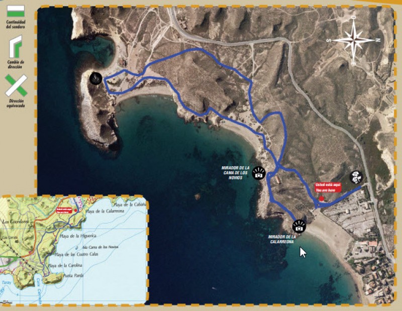
Details of the SL-MU 18 Cuatro Calas walk
Start and finish: Playa de Calarreona
Distance: 4 kilometres including detours, 2.8 km without detours
Duration: 60 minutes for the circular route, 90 minutes including detours
Total ascent and descent: 130 metres
The SL-MU 18 “Cuatro Calas” footpath follows a route which is entirely within the protected landscape of Cuatro Calas, or four coves, and thus allows walkers to appreciate the cultural and natural aspects which led to protected status being awarded to the area. Cuatro Calas has also been included by the European Commission in the Natura 2000 network as a Site of Community Interest, and contains the Cañada Brusca salt marsh, which is a candidate to become a botanical micro-reserve, and the volcanic outcrop of Punta Parda, which has been proposed as a Site of Geological Interest.
The “Four Coves” referred to in the name given to the area are the long beach of Calarreona and those of La Carolina, Cala Cerrada and La Higuerica.
The walk follows a circular route with two small optional offshoots, and is on well-worn paths with very few slopes or other elements of difficulty, giving walkers the opportunity to vary both the time taken on the walk and the distance.
The first optional offshoot is right at the start, taking walkers 200 metres back to the main road to view Cañada Brusca, and after this the path joins the GR-92 route, which runs from Águilas all along the Mediterranean coast to the border with France.
The second offshoot is at the old Guardia Civil building in Calarreona, and allows walkers to reach viewing points with magnificent views over all of the beaches, headlands and islands in the area. The route departs from the GR-92 at the Playa de la Carolina and heads for Cala Cerrada and the volcanic outcrop of Punta Parda, taking in spectacular sculpted erosions and the basins which were used in the past to soak esparto grass in order to change its consistency and make it more pliable for weaving.
The return loop of the route follows paths which are slightly further inland.
Click for route pdf in English and Spanish
Features to look out for along the route
Is there life in Cañada Brusca?
The answer is yes! There is an unusual combination of salsola, amaranths, sempreviva and barilla which have managed to find a way to survive in the hostile salty soil. The saltmarsh of Cañada Brusca, which lies inland from the Playa de la Higuerica, is home to vulnerable plant species such as the “salao” (Salsola papillosa) and the tamarisk, or salt cedar (Tamarix boveana), although perhaps the star of the show from a botanical point of view is an endangered salsola, the Halocnemun strobilaceum. In the whole of the Iberian Peninsula this species exists in the wild only in a few areas of south-eastern Spain.
At the edges of the salt marsh is another botanical jewel, the “jarilla de Mota”. This plant was not identified until 2011, and was named in reference to the Águilas botanist who discovered it, Juan Francisco Mota Poveda: it is known to grow only in Cañada Brusca and in San Juan de los Terreros, just down the coast in the province of Almería.
What’s cooking here?
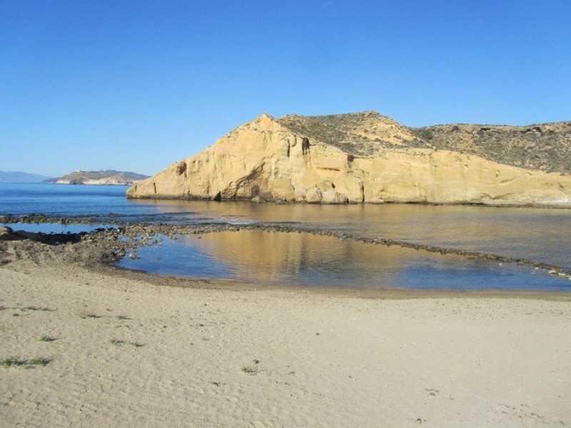
At Cala Cerrada, also known as the Cala de los Cocedores, there are seawater pools which were used in the past to treat (or “cook”) esparto grass, as by leaving the grass under the seawater its fibre became softer and took on a different colour. After soaking here for a period of around three weeks the grass was then dried and crushed, in order to obtain finer fibres.
Esparto grass-related industries, it should be explained, were crucial for the local economy of Águilas throughout the 19th century and much of the 20th and esparto was widely exorted by the Romans during their period of occupation (see History of Águilas for further information)
The hidden volcano
Hidden from sight on the southern side of the headland of Punta Parda, the headland which separates Playa de la Carolina from Cala Cerrada, is one of the most spectacular volcanic outcrops in the Region of Murcia, consisting of a cliff formed by ash, pyroclasts, breccia and agglomerates which now tower over the shore below. This geological feature, which is similar to the tiny islets of Isla Negra and Isla de Terreros a little further to the south-west, was created by fissures on fault lines, and some even believe that it is related to the volcanic complex of Cabo de Gata.
Salsola and the birth of Águilas
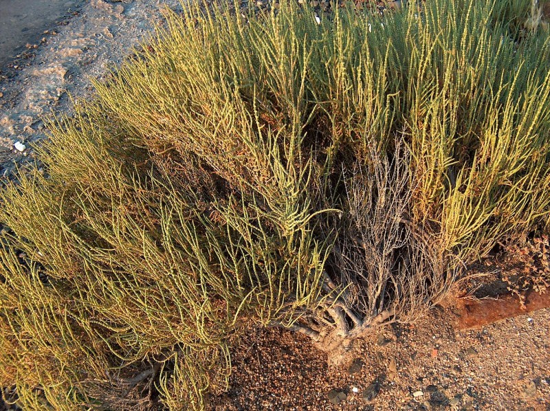
It might seem surprising, but the modest and sometimes reviled salsola plant, which looks almost like a weed, could well have been responsible for the town of Águilas continuing to exist after the Middle Ages.
This plant was commonly used in the past for making soap, potash and soda ash, and by the 18th century the port of Águilas was one of the most important in the Mediterranean in terms of supplying these products to the rest of Europe and northern Africa. This trading gave rise to a substantial group of merchants around the port and the subsequent repopulation of the town, along with the impetus provided by administrators and politicians such as Antonio Robles Vives and the Count of Floridablanca.
Although salsola is no longer viewed as valuable, it still exists in abundance in the area covered by the Cuatro Calas walk in Águilas.
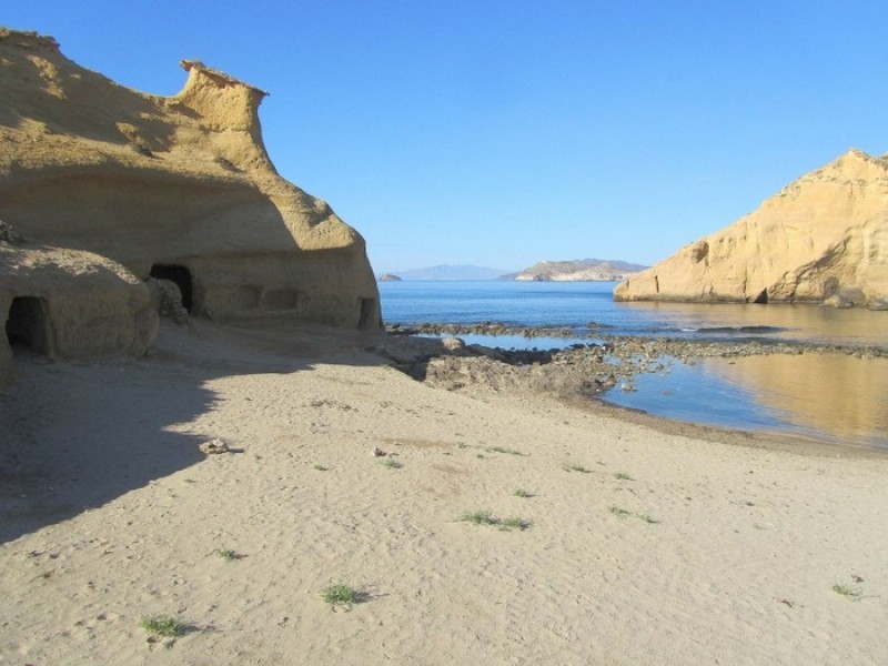
Sculptures of Nature
The silhouettes of the rock formations in Cala Cerrada and Playa de la Carolina have become the sight which is most readily associated with the protected landscape of the Cuatro Calas area of Águilas, and are a complex combination of protruding ledges and other unusual geological shapes. The curious “sculptures” were formed over time by the different speeds of erosion of the materials which are present in the headlands: marls, yellow silt and limestones are worn away relatively quickly, while the more resistant materials on top resist the processes of erosion.
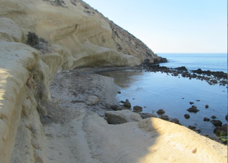
Campus Spartarius
This was one of the names given to the south-east of Hispania (the Iberian Peninsula) by the Romans due to the abundance of esparto grass which grew here, and ever since then the grass has been used to make numerous tools and household objects, including sandals, baskets, mats, yokes, storage vessels and slings. So versatile is the grass that it was also used to create ropes and even paper, giving rise to an industry which was the pillar of the local economy in Águilas between the end of the Civil War in 1939 and the arrival of tourism in the 1960s.
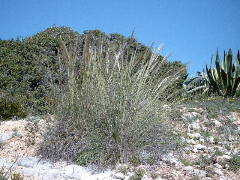
Esparto grass is no longer important in economic terms but it is still important to the environment, as its roots prevent the soil in which it grows from being eroded, and it is abundant in the area of the Cuatro Calas walk in Águilas. Alongside it grow other species such as buckthorns, “cornical” (Periploca angustifolia) and even one species which is endemic to Murcia and the province of Almería, namely a type of salsola which is known as “escobilla” (Salsola genistoides).
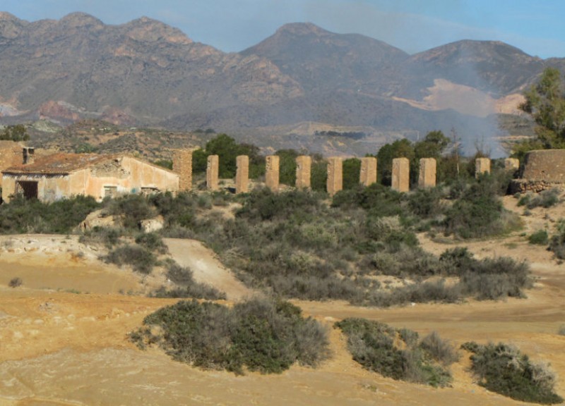
Impregnable fortresses
When the sea erodes the base of the promontories along the coast the resulting rock falls can produce a chaotic landscape of boulders and cliffs, and many of the inaccessible nooks and crannies in the Cuatro Calas area of Águilas are used as refuges and nesting areas by birds such as the Alpine swift (Tachymarptis melba), the common kestrel (Falco tinnunculus) and the peregrine falcon (Falco peregrinus). Also found here is one of the species which could fall prey to the latter two, the rock dove (Columba livia), which performs a series of perilous pirouettes as it approaches the rocks in order to avoid being attacked.
The dunes are alive!
The sand along this part of the Águilas coastline has a life of its own, if it is allowed to live it: propelled by the wind, it forms dynamic dune systems which move as if of their own accord if no obstacles are placed in their way. In addition, if they are not flattened by motor vehicles and walkers, they are inhabited by an interesting collection of plant species which are capable of surviving in the extreme conditions, withstanding a moving substratum, a complete lack of soil humidity, high salt content and the salty sea breeze.
One example is the species known as marram grass or beach grass (Ammophila arenaria), whose rootstalks cling to the waves of sand. Others include the coastal medick (whose leaves reflect the powerful rays of the sun), the European searocket (which keeps water stored in its leaves) and the sea daffodil, with its spectacular white flowers and a water-containing bulb under the ground. In among these plants Kentish plovers can be seen hopping around and searching for a place to nest, while spiny-footed lizards scurry away from the birds when they are surprised while basking in the sun.
Recommendations
• The route lies in a protected area, and it is therefore necessary to comply with conservation rules and respect the environment at all times.
• Do not leave the marked path, as vegetation can be destroyed by being trodden on and erosion can be caused.
• Rubbish should be deposited in the containers provided.
• Be aware of the risk of fire! The consequences of fires in areas like this can be irreparable.
• Sound is part of the landscape, and noise which can disturb wildlife should be avoided.
• Archaeological remains, historic buildings, rocks, minerals, fossils, plants and animals are common heritage, and are indispensable elements of our history and environment. Collecting or damaging them is subject to punishment by law.
Click here for further information about the Águilas municipality: ÁGUILAS TODAY


